Garmin GPSMAP 723xsv - Chartplotter & Sonar

Garmin Garmin GPSMAP 723xsv -  Chartplotter & Sonar

Item: 010-02365-02

MPN: 010-02365-02

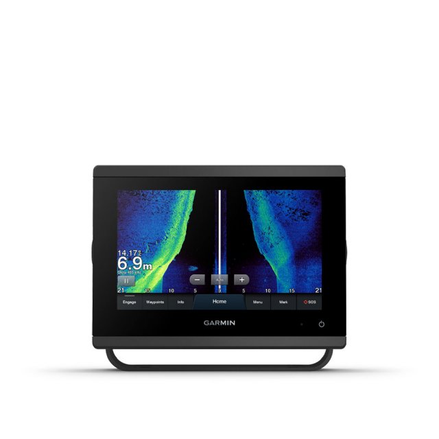
Get a sharper view from a connected helm with the GPSMAP 723 chartplotter. Its higher-resolution 7” display has 60% more pixels than previous-generation touchscreens. And with its compact footprint, vivid sonar colour palette and nearly double the processing power of previous-generation GPSMAP devices, it seamlessly integrates into your Garmin marine system. The GPSMAP 723xsv also features built-in Ultra High-Definition SideVü and ClearVü scanning sonars and supports 1 kW CHIRP traditional sonar as well as fully networkable radar, Panoptix LiveScope sonar and Auto Guidance technology.

Write the first review

£1,079.99
RRP £1187.99

updown

Product Description

Easily integrate with more engines Connect to compatible third-party devices with OneHelm digital switching Easily build a marine system using the best of network connectivity Compatible with premium maps and charts for the best in Garmin navigation Take the guesswork out of sailing with clear laylines and more - right on the screen Manage the marine experience from nearly anywhere <style> @media only screen and (max-width: 1023px) .ten } @media only screen and (min-width: 1024px) } .page-header, .product-image-wrapper, .navigation .navigation:hover .page-header:hover .modalDialog .modalDialog:target .modalDialog>div .stop-button .stop-button:hover #compatibility #compatibility td,' #customers th #compatibility tr:nth-child(even) #compatibility tr:hover #compatibility th .modal-header .modal-title .modal-footer .modal-body </style> <div id''links''> <a class''pagebuilder-button-primary'' href''#openModal'' style''text-align: center; font-weight: normal;''> <i class''fas fa-wrench''></i> <span data-element''link_text'' style''font-weight: 600;''> Specification</span> </a> <a class''pagebuilder-button-primary'' href''https://www8.garmin.com/manuals/webhelp/GUID-3E67C80C-0812-4EEC-BC60-699751B9CF6F/EN-US/GPSMAP_x3_OM_EN-US.pdf'' target''_blank'' style''text-align: center; font-weight: normal;''> <i class''fas fa-book''></i> <span data-element''link_text'' style''font-weight: 600;''> Manual</span> </a> <a class''pagebuilder-button-primary'' href''https://www8.garmin.com/manuals/webhelp/GUID-BF2FF273-008A-482A-A96F-362ADA8996BA/EN-US/GPSMAP_7x3_9x3_12x3_Install_EN-US.pdf'' target''_blank'' style''text-align: center; font-weight: normal;''> <i class''fas fa-wrench''></i> <span data-element''link_text'' style''font-weight: 600;''> Installation</span> </a> <a class''pagebuilder-button-primary'' href''https://static.garmin.com/pumac/GPSMAP_7x3_flush_template.pdf'' target''_blank'' style''text-align: center; font-weight: normal;''> <i class''far fa-file-image''></i> <span data-element''link_text'' style''font-weight: 600;''> Template</span> </a> </div> <div id''openModal'' class''modalDialog''> <div> <div class''modal-header''> <h3 class''modal-title''>Technical Specifications</h3> <a class''stop-button'' title''Close'' href''#close'' onclick''go()''>X</a> </div> <div class''modal-body''> <table id''compatibility''> <thead> <tr> <th colspan''2''><strong>General</strong></th> </tr> </thead> <tbody> <tr> <td>Dimensions</td> <td>19.2 x 14 x 7.4CM (7.6'' x 5.5'' x 2.9'')</td> </tr> <tr> <td>Input</td> <td>Touchscreen</td> </tr> <tr> <td>Display Size</td> <td>15.4 x 9.1cm',' 17.8cm (7'') Diagonal</td> </tr> <tr> <td>Display Resolution</td> <td>1024 x 600 pixels</td> </tr> <tr> <td>Display Type</td> <td>WSVGA Display</td> </tr> <tr> <td>Weight</td> <td>1.3Kg</td> </tr> <tr> <td>Water Rating</td> <td>IPX7</td> </tr> <tr> <td>Mounting Options</td> <td>Bail',' Flush or Flat</td> </tr> </tbody> </table> <br> <table class''half'' id''compatibility''> <thead> <tr> <th colspan''2''><strong>Maps & Memory</strong></th> </tr> </thead> <tbody> <tr> <td>Accepts Data Cards</td> <td>2 microSD Cards (back of unit)</td> </tr> <tr> <td>Waypoints</td> <td>5',000</td. </tr> <tr> <td>Track Points</td> <td>50,'000</td> </tr> <tr> <td>tracks</td> <td>50 Saved Tracks</td> </tr> <tr> <td>Navigation Routes</td> <td>100</td> </tr> </tbody> </table> <br> <table class''half'' id''compatibility''> <thead> <tr> <th colspan''2''><strong>Sensors</strong></th> </tr> </thead> <tbody> <tr> <td>Built-in Receiver</td> <td>?</td> </tr> <tr> <td>Receiver</td> <td>10 Hz High-sensitivity</td> </tr> <tr> <td>NMEA 2000 Compatible</td> <td>?</td> </tr> <tr> <td>NMEA 0183 Compatible</td> <td>?</td> </tr> <tr> <td>GPS</td> <td>?</td> </tr> <tr> <td>GLONASS</td> <td>?</td> </tr> <tr> <td>GALILEO</td> <td>?</td> </tr> <tr> <td>Supports WAAS</td> <td>?</td> </tr> </tbody> </table> <br> <table class''half'' id''compatibility''> <thead> <tr> <th colspan''2''><strong>Built-in Maps</strong></th> </tr> </thead> <tbody> <tr> <td>Built-in Auto Guidance</td> <td>?</td> </tr> <tr> <td>BlueChart (Coastal)</td> <td>?</td> </tr> <tr> <td>LakeVu (Inland)</td> <td class''ten''>?</td> </tr> <tr> <td>Tidetables</td> <td class''ten''>?</td> </tr> </tbody> </table> <br> <table class''half'' id''compatibility''> <thead> <tr> <th colspan''2''><strong>Optional Map Support</strong></th> </tr> </thead> <tbody> <tr> <td>LakeVu G3</td> <td class''ten''>?</td> </tr> <tr> <td>LakeVu G3 Ultra</td> <td class''ten''>?</td> </tr> <tr> <td>Garmin Navionics+</td> <td class''ten''>?</td> </tr> <tr> <td>Garmin Navionics Vision+</td> <td class''ten''>?</td> </tr> <tr> <td>TOPO</td> <td class''ten''>?</td> </tr> <tr> <td>Standard Mapping</td> <td class''ten''>?</td> </tr> <tr> <td>Garmin Quickdraw Contours</td> <td class''ten''>?</td> </tr> <tr> <td>Raster Chart Support</td> <td>?</td> </tr> </tbody> </table> <br> <table class''half'' id''compatibility''> <thead> <tr> <th colspan''2''><strong>Chartplotter Features</strong></th> </tr> </thead> <tbody> <tr> <td>Garmin Smartmode Compatible<br>(Customisable Monitor Presets)</td> <td>?</td> </tr> <tr> <td>AIS</td> <td class''ten''>?</td> </tr> <tr> <td>DSC</td> <td class''ten''>?</td> </tr> <tr> <td>Fusion-Link</td> <td class''ten''>?</td> </tr> <tr> <td>GSD Black Box Sonar Support</td> <td>?</td> </tr> <tr> <td>GCV Black Box Sonar Support</td> <td>?</td> </tr> <tr> <td>ActiveCaptain App Compatible</td> <td class''ten''>?</td> </tr> <tr> <td>GRID (Garmin Remote Input Device) Compatible</td> <td>?</td> </tr> <tr> <td>Wireless Remote Compatible</td> <td class''ten''>?</td> </tr> <tr> <td>Sailing Features</td> <td class''ten''>?</td> </tr> <tr> <td>Spoken Audo Alerts</td> <td>?</td> </tr> <tr> <td>OneHelm Support</td> <td>?</td> </tr> </tbody> </table> <br> <table id''compatibility''> <thead> <tr> <th colspan''2''><strong>Sonar Features & Specifications</strong></th> </tr> </thead> <tbody> <tr> <td>Displays Sonar</td> <td>?</td> </tr> <tr> <td>Power Output</td> <td>1kW</td> </tr> <tr> <td>Traditional Sonar</td> <td>Built-in (Single channel CHIRP', 70/83/200kHz, L,M,'H CHIRP)</td> </tr> <tr> <td>ClearVu</td> <td>Built-in 260/455/800/1000/1200kHz</td> </tr> <tr> <td>SideVu</td> <td>Built-in 260/455/800/1000/1200kHz</td> </tr> <tr> <td>Panoptix Sonar</td> <td>?</td> </tr> <tr> <td>Livescope</td> <td>?</td> </tr> </tbody> </table> <br> <table class''half'' id''compatibility''> <thead> <tr> <th colspan''2''><strong>Connections</strong></th> </tr> </thead> <tbody> <tr> <td>NMEA 2000 Ports</td> <td>1</td> </tr> <tr> <td>NMEA 0183 Input Ports</td> <td>1 Diffential</td> </tr> <tr> <td>NMEA 0183 tx Ports</td> <td>1</td> </tr> <tr> <td>Video Input Ports</td> <td>1 BNC</td> </tr> <tr> <td>J1939 Ports</td> <td>1</td> </tr> <tr> <td>Garmin Marine Network Ports</td> <td>1</td> </tr> <tr> <td>12-Pin Transducer Ports</td> <td>1</td> </tr> <tr> <td>USB Ports</td> <td>?</td> </tr> <tr> <td>BNC External GPS Antenna Ports</td> <td>?</td> </tr> <tr> <td>Bluetooth Calling</td> <td>?</td> </tr> <tr> <td>ANT+ Connectivity</td> <td>?</td> </tr> <tr> <td>Garmin Wi-Fi Network</td> <td>?</td> </tr> </tbody> </table> <br> <table class''half'' id''compatibility''> <thead> <tr> <th colspan''2''><strong>Electrical Features</strong></th> </tr> </thead> <tbody> <tr> <td>Power Input</td> <td>10 - 32 VDC</td> </tr> <tr> <td>Typical Current Draw at 12V</td> <td>1.18A</td> </tr> <tr> <td>Max Current at 12V</td> <td>2.96A</td> </tr> <tr> <td>Max Power Use at 10V</td> <td>35.9W</td> </tr> </tbody> </table> </div> </div> </div>Get A Sharper View From A Connected Helm With 60% more display pixels and nearly double the processing power of previous-generation 7-inch GPSMAP devices', this crisp high-resolution chartplotter integrates seamlessly into your Garmin marine system. Sail And Navigate With Ease Faster, Sharper, Smarter - With its added processing power and new slimline design featuring edge-to-edge glass and a smaller unit footprint, it’s easy to retrofit this 7-inch plotter in a wider range of dash configurations. Improved Display Optics - New higher-resolution 7-inch displays offer improved sunlight readability with 60% more pixels than previous-generation 7-inch GPSMAP devices. Garmin SailAssist Sailing Features - View laylines, race start line guidance, enhanced wind rose, heading and course-over-ground lines, true wind data fields and tide/current/time slider, wind angle, set and drift, wind speed and more. Optional BlueChart G3 Vision Charts - These optional charts offer the best of Garmin and Navionics data, Auto Guidance technology and other premium navigation features. Connect To Everything On The Boat Garmin Marine Network - Share information - such as maps, user data, radar and IP camera video among multiple compatible Garmin devices on the boat. NMEA 2000 And NMEA 0183 Networks - Connect to compatible autopilots, digital switching, weather, Fusion-Link audio system, media, VHF, AIS and more from one screen. ActiveCaptain App - Built-in Wi-Fi connectivity pairs with the free all-in-one mobile app for access to the OneChart feature, smart notifications, software updates, Garmin Helm digital switching, Garmin Quickdraw Community data and more. Integrated ANT Technology - Connect with some of your favourite devices, such as quatix marine watches, gWind Wireless 2 transducers transducers, GNX Wind marine instruments and wireless remote controls. J1939 Connectivity - Now you can connect the chartplotter to different kinds of engines, including select Yamaha engines. OneHelm Feature - This exclusive feature brings together all the operations and capabilities of select third-party devices, such as EmpirBus digital switching, on one screen. See The World Below Panoptix Sonar Support - Pair with Panoptix or Panoptix LiveScope easy-to-interpret live sonar (transducer sold separately) with FrontVü scanning sonar to help you see and avoid submerged obstacles in real time as you approach within a 91-metre range. In The Box GPSMAP 723xsv chartplotter microSD card preinstalled Power cable NMEA 2000 T-connector NMEA 2000 drop cable (2 metres) 8-pin transducer to 12-pin sounder adapter cable Bail mount kit with knobs Flush mount kit with gasket Protective cover Trim piece snap covers Documentation

Product Features

  • Weight: 2700g
  • Dimensions: D:29cm W:22.5cm H:20.8cm
Custom Delivery Required

Delivery price on application.

You Can Also...

Get help or write a review...

ask a questionwrite a review