
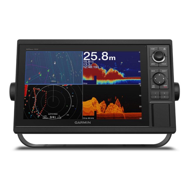
Garmin GPSMAP 1222xsv Chartplotter & Sonar


Item: 010-01741-02
MPN: 010-01741-02
GPSMAP 1222 is designed for cruisers, blue water cruisers and racers who need the advanced all-in-one solution. Featuring a 12-inch bright screen and easy to use interface and are compatible with the Garmin Marine Network. GPSMAP 1222xsv Chartplotter with CHIRP, ClearVu & SideVu Sonar
Product Description
Get wider viewing angles on a vivid 12″ colour display Compatible with Garmin's premium maps and charts for the best in navigation Share information among multiple units',' thanks to Garmin Marine Network support See fluid position and heading changes with update rates of 10 times per second Easily transfer waypoints',' tracks and routes from other GPS devices See what’s around the boat with built-in sonar capabilities (transducers sold separately) <style> @media only screen and (max-width: 1023px) .ten } @media only screen and (min-width: 1024px) } .page-header, .product-image-wrapper, .navigation .navigation:hover .page-header:hover .modalDialog .modalDialog:target .modalDialog>div .stop-button .stop-button:hover #compatibility #compatibility td,' #customers th #compatibility tr:nth-child(even) #compatibility tr:hover #compatibility th .modal-header .modal-title .modal-footer .modal-body </style> <div id''links''> <a class''pagebuilder-button-primary'' href''#openModal'' style''text-align: center; font-weight: normal;''> <i class''fas fa-wrench''></i> <span data-element''link_text'' style''font-weight: 600;''> Specification</span> </a> <a class''pagebuilder-button-primary'' href''https://www8.garmin.com/manuals/webhelp/gpsmap1002-1202/EN-US/GPSMAP_10x2-12x2_Keyed_OM_EN-US.pdf'' target''_blank'' style''text-align: center; font-weight: normal;''> <i class''fas fa-book''></i> <span data-element''link_text'' style''font-weight: 600;''> Manual</span> </a> <a class''pagebuilder-button-primary'' href''https://www8.garmin.com/manuals/webhelp/GUID-BF1B0D74-52BF-4F5B-938B-9A7556F36E8C/EN-US/GPSMAP_10x2-12x2_Keyed_Install_EN-US.pdf'' target''_blank'' style''text-align: center; font-weight: normal;''> <i class''fas fa-wrench''></i> <span data-element''link_text'' style''font-weight: 600;''> Installation</span> </a> <a class''pagebuilder-button-primary'' href''https://static.garmin.com/pumac/GPSMAP_12x2_flush_template.pdf'' target''_blank'' style''text-align: center; font-weight: normal;''> <i class''far fa-file-image''></i> <span data-element''link_text'' style''font-weight: 600;''> Template</span> </a> </div> <div id''openModal'' class''modalDialog''> <div> <div class''modal-header''> <h3 class''modal-title''>Technical Specifications</h3> <a class''stop-button'' title''Close'' href''#close'' onclick''go()''>X</a> </div> <div class''modal-body''> <table id''compatibility''> <thead> <tr> <th colspan''2''><strong>General</strong></th> </tr> </thead> <tbody> <tr> <td>Dimensions</td> <td>35.8 x 22.6 x 6.9 cm</td> </tr> <tr> <td>Input</td> <td>Keyed</td> </tr> <tr> <td>Display Size</td> <td>26.2 x 16.3 cm',' 30.7cm (12.1'') Diagonal</td> </tr> <tr> <td>Display Resolution</td> <td>1280 x 800 pixels</td> </tr> <tr> <td>Display Type</td> <td>WXGA Display</td> </tr> <tr> <td>Weight</td> <td>2.34Kg</td> </tr> <tr> <td>Water Rating</td> <td>IPX7</td> </tr> <tr> <td>Mounting Options</td> <td>Bail',' or Flush</td> </tr> </tbody> </table> <br> <table class''half'' id''compatibility''> <thead> <tr> <th colspan''2''><strong>Maps & Memory</strong></th> </tr> </thead> <tbody> <tr> <td>Accepts Data Cards</td> <td>2 SD Cards</td> </tr> <tr> <td>Waypoints</td> <td>5',000</td. </tr> <tr> <td>Track Points</td> <td>50,'000</td> </tr> <tr> <td>tracks</td> <td>50 Saved Tracks</td> </tr> <tr> <td>Navigation Routes</td> <td>100</td> </tr> </tbody> </table> <br> <table class''half'' id''compatibility''> <thead> <tr> <th colspan''2''><strong>Sensors</strong></th> </tr> </thead> <tbody> <tr> <td>Built-in Receiver</td> <td>✓</td> </tr> <tr> <td>Receiver</td> <td>10 Hz</td> </tr> <tr> <td>NMEA 2000 Compatible</td> <td>✓</td> </tr> <tr> <td>NMEA 0183 Compatible</td> <td>✓</td> </tr> <tr> <td>GPS</td> <td>✓</td> </tr> <tr> <td>GLONASS</td> <td>✓</td> </tr> <tr> <td>Supports WAAS</td> <td>✓</td> </tr> </tbody> </table> <br> <table class''half'' id''compatibility''> <thead> <tr> <th colspan''2''><strong>Built-in Maps</strong></th> </tr> </thead> <tbody> <tr> <td>Tidetables</td> <td class''ten''>✓</td> </tr> </tbody> </table> <br> <table class''half'' id''compatibility''> <thead> <tr> <th colspan''2''><strong>Optional Map Support</strong></th> </tr> </thead> <tbody> <tr> <td>LakeVu G3</td> <td class''ten''>✓</td> </tr> <tr> <td>LakeVu G3 Ultra</td> <td class''ten''>✓</td> </tr> <tr> <td>Garmin Navionics+</td> <td class''ten''>✓</td> </tr> <tr> <td>Garmin Navionics Vision+</td> <td class''ten''>✓</td> </tr> <tr> <td>TOPO</td> <td class''ten''>✓</td> </tr> <tr> <td>Standard Mapping</td> <td class''ten''>✓</td> </tr> <tr> <td>Garmin Quickdraw Contours</td> <td class''ten''>✓</td> </tr> <tr> <td>Raster Chart Support</td> <td class''ten''>✓</td> </tr> </tbody> </table> <br> <table class''half'' id''compatibility''> <thead> <tr> <th colspan''2''><strong>Chartplotter Features</strong></th> </tr> </thead> <tbody> <tr> <td>Garmin Smartmode Compatible (Custom Monitor Presets)</td> <td class''ten''>✓</td> </tr> <tr> <td>AIS</td> <td class''ten''>✓</td> </tr> <tr> <td>DSC</td> <td class''ten''>✓</td> </tr> <tr> <td>Fusion-Link</td> <td class''ten''>✓</td> </tr> <tr> <td>GSD Black Box Sonar Support</td> <td class''ten''>✓</td> </tr> <tr> <td>GCV Black Box Sonar Support</td> <td class''ten''>✓</td> </tr> <tr> <td>ActiveCaptain App Compatible</td> <td class''ten''>✓</td> </tr> <tr> <td>GRID (Garmin Remote Input Device) Compatible</td> <td class''ten''>✓</td> </tr> <tr> <td>Wireless Remote Compatible</td> <td class''ten''>✓</td> </tr> <tr> <td>Sailing Features</td> <td class''ten''>✓</td> </tr> </tbody> </table> <br> <table id''compatibility''> <thead> <tr> <th colspan''2''><strong>Sonar Features & Specifications</strong></th> </tr> </thead> <tbody> <tr> <td>Displays Sonar</td> <td>✓</td> </tr> <tr> <td>Power Output</td> <td>1kW</td> <tr> <td>Traditional Sonar</td> <td>Single Channel CHIRP 70/83/200kHz',' L/M/H CHIRP</td> </tr> <tr> <td>ClearVu</td> <td>Yes with CHIRP</td> </tr> <tr> <td>SideVu</td> <td>Yes with CHIRP</td> </tr> <tr> <td>Panoptix Sonar</td> <td>✓</td> </tr> <tr> <td>Livescope</td> <td>✓</td> </tr> </tbody> </table> <br> <table class''half'' id''compatibility''> <thead> <tr> <th colspan''2''><strong>Connections</strong></th> </tr> </thead> <tbody> <tr> <td>NMEA 2000 Ports</td> <td>1</td> </tr> <tr> <td>NMEA 0183 Input Ports</td> <td>1 Diffential</td> </tr> <tr> <td>Video Input Ports</td> <td>1 - BNC Composite</td> </tr> <tr> <td>Video Output Ports</td> <td>None</td> </tr> <tr> <td>Garmin Marine Network Ports</td> <td>2</td> </tr> <tr> <td>12 Pin Transducer Ports</td> <td>1</td> </tr> <tr> <td>Bluetooth Calling</td> <td>✓</td> </tr> <tr> <td>ANT+ Connectivity</td> <td>✓</td> </tr> <tr> <td>Garmin Wi-Fi Network</td> <td>✓</td> </tr> </tbody> </table> <br> <table class''half'' id''compatibility''> <thead> <tr> <th colspan''2''><strong>Electrical Features</strong></th> </tr> </thead> <tbody> <tr> <td>Power Input</td> <td>10 - 32 VDC</td> </tr> <tr> <td>Typical Current Draw at 12V</td> <td>2.2A</td> </tr> <tr> <td>Max Current at 12V</td> <td>2.9A</td> </tr> <tr> <td>Max Power Use at 10V</td> <td>34.8W</td> </tr> </tbody> </table> </div> </div> </div>Experience an advanced all-in-one solution with our 12-inch GPSMAP 1222xsv keyed combo. Includes built-in support for Garmin CHIRP sonar', CHIRP ClearVü and CHIRP SideVü. It also supports Panoptix all-seeing sonar and premium Garmin sonar modules (transducers sold separately). Features a large, bright screen coupled with a quick and easy-to-use keypad interface with user-programmable keys and a multifunction control knob. Garmin Marine Network and NMEA 2000 SupportFull-network compatibility allows you to add more capabilities to your boat. Garmin Marine Network support allows sharing of sonar, including Panoptix FrontVü collision avoidance sonar, maps, user data, dome or open-array radar and IP cameras among multiple units. Plus, there’s NMEA 2000 network connectivity and NMEA 0183 support for autopilots, digital switching, weather, FUSION-Link, VHF, AIS and other sensors. Built-in ANT® ConnectivityEnjoy built-in ANT wireless connectivity directly to quatix® marine watch, Garmin Nautix™ in-view display, gWind™ Wireless 2 transducer, GNX™ Wind marine instrument and wireless remote controls. Built-in Sonar CapabilitiesRight out of the box, you have access to some amazing sonar capabilities; all you have to add are transducers. Comes with built-in Garmin 1 kW CHIRP sonar, CHIRP ClearVü and CHIRP SideVü scanning sonar. It even supports Panoptix all-seeing sonar, premium Garmin sonar modules and a wide range of transducers (sold separately). Networked combos can share their internal sonar with any other device on the network. You can also choose what information is overlaid on the sonar screen; for example, radar, time of day or GPS speed. The Ultimate Connected Boating AppBuilt in Wi-Fi gives you access to the free all-in-one ActiveCaptain app, so you can manage your marine experience from nearly anywhere. It creates a simple yet powerful connection between your compatible mobile device and your Garmin chartplotter, charts, maps and the boating community. Wherever you are, you’ll have unlimited access to your cartography, the ability to purchase new maps and charts and access to the Garmin Quickdraw™ Contours Community. Stay connected with smart notifications on your chartplotter screen. You can also plan a trip or prefish a lake, and ActiveCaptain will automatically sync with your chartplotter. Even get notifications for software updates, and decide when to download them on your device. Heading, Position Refreshed 10 Times per SecondFast, responsive built-in 10 Hz GPS and GLONASS receiver refreshes your position and heading 10 times each second to make your movement on the screen more fluid. It makes dropping up to 5,000 accurate waypoints — and finding your way back to them — quick and easy. Built-in Sail Assist FeaturesTo help you gain a wind-maximising competitive edge, your chartplotter features a pre-race guidance page that shows your virtual starting line along with data fields showing laylines, time to burn before the start and a race timer that can be synchronised across all your networked Garmin GPS products. In addition, other supported sailing features include an enhanced wind rose, heading and course-over-ground lines, set and drift, true and apparent wind data and more. GPX Waypoints TransferIf you have waypoints, tracks or frequently used routes stored on another manufacturer’s GPS product — or on a Garmin handheld device — it’s easy to transfer those items to your new Garmin chartplotter via industry-standard GPX software formatting. Garmin BlueChartThe GPSMAP 1222 chartplotter Supports optional BlueChart® g2 Vision® HD charts for Auto Guidance and other premium navigation features. Two SD™ card slots provide expandable memory for accessory map purchases, such as BlueChart® g2 HD or BlueChart® g2 Vision® HD,' which adds Garmin patented Auto Guidance¹ and other great features. In The Box GPSMAP 1222xsv chartplotter Power/data cable NMEA 2000 T-connector NMEA 2000 drop cable (2 m) 8-pin transducer to 12-pin sounder adapter cable Bail mount kit with knobs Flush mount kit with gasket Protective cover Trim piece snap covers Documentation #html-body [data-pb-style''6390725570E1B'']#html-body [data-pb-style''6390725570E25'']#html-body [data-pb-style''6390725570E2C'']#html-body [data-pb-style''6390725570E32'']#html-body [data-pb-style''6390725570E38'']Collect in Store
This item is available for collection.
You may also like...

People who bought this also bought...