
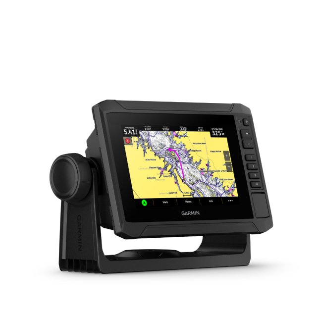
Garmin ECHOMAP UHD2 Touch 65sv Chartplotter


Item: 010-02682-10
MPN: 010-02682-10
The 6” ECHOMAP UHD2 touchscreen with keyed-assist chartplotter knows the water better than a local. Get clear, high-contrast views all around the boat with support for Garmin traditional, ClearVü and SideVü scanning sonars. Navigate the waters with preloaded Garmin Navionics+ charts for the U.K., Ireland, and the Netherlands.
Product Description
- The bright 6" touchscreen display with keyed-assist is user-friendly and easy to read
- Good things come in threes. Supports three sonar types: Garmin traditional, ClearVü and SideVü sonars
- Improved detail? Check. Distinguished targets? Yep. That’s the beauty of high-contrast vivid colour palettes
- Wirelessly share sonar, waypoints and routes with another ECHOMAP UHD2 chartplotter
- Comes preloaded with Garmin Navionics+ mapping for U.K., Ireland and the Netherlands.
Dimensions20.6 x 13.1 x 6.7 cm (5.4" x 5.2" x 2.6")
InputTouchscreen with Keyed Assist
Display Size13.8 x 7.8cm, 15.7cm Diagonal (5.4" x 3.1", 6.2" Diagonal)
Display Resolution800 x 480 Pixels
Display TypeWVGA, TNWeight0.8Kg (1.8lbs)
Water RatingIPX7
Mounting OptionsBail or Flush
Know The Water Better Than A Local
When it comes to catching more fish, they say, "talk to a local." With the ECHOMAP UHD2 chartplotter, which offers support for Garmin's best-in-class sonar, built-in Garmin Navionics+ for U.K and Ireland, and a premium touchscreen display with keyed-assist, know the water even better than they do.
It Doesn't Get Any Better Than This
Sonar Support - With support for crisp, clear traditional sonar and brilliant ClearVü and SideVü scanning sonars, the fish will have nowhere to hide. The ECHOMAP UHD2 also supports LiveScope live-scanning sonar.
Vivid Colour Palettes - High-contrast vivid scanning sonar colour palettes make it easier than ever to distinguish targets and structure.
Preloaded Charts - Chartplotters come with built-in Garmin Navionics+ cartography for U.K., Ireland and the Netherlands which includes a 1-year subscription for daily updates, raster cartography and more.
Wireless Networking - Wirelessly share information such as sonar, waypoints and routes with another compatible ECHOMAP UHD2 chartplotter on the boat.
ActiveCaptain App - Built-in Wi-Fi connectivity pairs with the free all-in-one mobile app for access to the OneChart feature, smart notifications, software updates, Garmin QuickDraw Community data and more.
Auto Guidance Technology - Built-in Garmin Navionics+ charts for U.K., Ireland and the Netherlands include downloadable Auto Guidance+ technology with the ActiveCaptain app.
Troll With Force - The ECHOMAP UHD2 chartplotter wirelessly connects to Garmin Force Trolling Motors to create and follow routes, navigate to waypoints, control speed, check battery life and more.
Multi-Band GPS - Get improved position accuracy, particularly in areas where signals are reflected or weak, with multi-band GPS.
In The Box
- ECHOMAP UHD2 65sv
- 12-pin sounder to 8-pin transducer cable
- Power cable
- Tilt/swivel mount with quick release cradle
- Protective cover
- Hardware
- Documentation
Collect in Store
This item is available for collection.
People who bought this also bought...